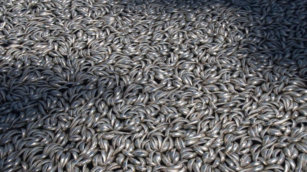
Ocean “dead zones” — regions of the sea where oxygen is severely or entirely depleted and most forms of life can’t survive — are booming worldwide, and scientists warn that they will continue to increase. Even outside these near-lifeless ocean regions, influxes of nutrient pollution are throttling oxygen levels in the open ocean and in coastal areas, threatening communities of sea life around the world. And less oxygen in the ocean doesn’t just spell trouble for marine plants and animals — it could carry serious repercussions for life on land as well.

While water molecules contain oxygen atoms, liquid water must also contain dissolved oxygen in order for fish and other organisms to breathe. Oxygen-deprived dead zones were first identified in estuaries — bodies of water where rivers flow into the sea — in the mid-19th century, and their oxygen depletion was linked to the presence of urban sewage in the water.
Since then, growth of industrial and agricultural activity has disrupted the ocean’s chemical balance, with regions in many areas worldwide becoming infused with pollutants and nutrients that starved the water of oxygen. Meanwhile, rising surface water temperatures hamper oxygen’s solubility in water and restrict its distribution into the deeper ocean. At the same time, some forms of marine life have grown increasingly stressed due to more acidic oceans, which increases their oxygen requirements.
Over the past 50 years, the ocean suffered a loss of about 85 billion tons (77 billion metric tons) of oxygen, affecting an accumulated area approximately the size of the European Union. Globally, the amount of zero-oxygen ocean water has quadrupled, while the area occupied by low-oxygen zones has increased by 10 times. In coastal areas and seas that are semi-enclosed, once low-oxygen conditions are established, they can persist for thousands of years.
It's one to watch...Is a major quake about to hit the Iran-Iraq border as more than 100 small to large quakes have hit the area in the last eleven hours, with 17 of them in the mag 5+ range with the biggest recorded at mag 5.5.
The Big Wobble has been keeping an eye on Iran since the magnitude 7.3 struck in November which killed 350 people and injuring 4,000.
It is one of the most active quake areas in the world and Iran also has 5 nuclear sites and 3 research reactors with the Bushehr nuclear site actually built right on top of a tectonic fault line, it is an accident waiting to happen.
Iran was struck by three more big quakes when a mag 6.0 and two magnitude 5.1 aftershocks rocked the Bushehr Nuclear site, which actually sits on a fault line.
Two weeks later another mag 6.0 -struck 64km NNE of Kerman, Iran smack in the middle of three uranium mines and the Bushehr nuclear site.
On December the 30th Iran was under the earthquake cosh once more as more than 50 quakes struck in just 10 hours with several of them larger than magnitude 4 on the Richter scale.
A coronal hole is facing the Earth at this moment and yesterday one of the biggest ever quakes struck the Caribbean.
As promised yesterday due to a coronal hole on our sun facing earth major quakes are a possibility in the next couple of days see here.
A magnitude 6.0 - 39km WSW of Pyu, Burma (Myanmar) is the second major quake of January 2018.
It comes after yesterday's magnitude 7.8 earthquake off the coast of Honduras which was one of the most powerful earthquakes ever recorded in the region.
As the first major quakes of 2018 struck in the last couple of days it should come as no surprise as a new coronal hole faces Earth.
After a quiet period the two are the first major quakes in almost a month.
Solar wind flowing from this coronal hole will reach Earth and cause polar geomagnetic activity on Jan. 13th.
Until then we could be in for more major quakes.
The days before the solar winds arrive can be a vulnerable time on our planet for earthquakes, as seen in the last two days.
Coronal holes are also known to influence other aspects here on Earth they are known to cause problems for animals who rely on the Earth's magnetic field to migrate.
The solar wind is also known to cause seizures and migraines in humans and behaviour problems in children and animals.
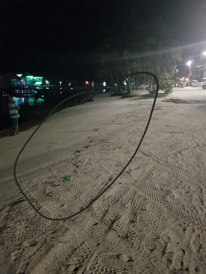
...very strong M7.6 earthquake forecast struck near the Great Swan Island, Honduras. Pressure is still being released as a series of aftershocks spreads like hell. Now one of the most impressive consequence of this earthquake was the water receding from several beaches in San Pedro, Belize as tsunami warning was claimed for Belize and Honduras! Look by yourself:
12:30AM: THE OCEAN CONTINUES TO RECEDE IN SAN PEDRO. BELIZE AS THE TSUNAMI THREAT CONTINUES FOR BELIZE AND HONDURAS.STAY AWAY FROM COASTAL AREAS IF YOU RESIDE IN BELIZE OR HONDURAS’ CARIBBEAN COASTS!VIDEO: BREAKING NEWS BELIZE PIC.TWITTER.COM/YLI1A8SM5X— TTWEATHERCENTER (@TTWEATHERCENTER) JANUARY 10, 2018
1-2 hours after the quake, minor tsunami waves (up to 30 cm / 0.98 feet) have been observed:
Now here a few pictures of the water receding in San Pedro, Belize


Only days before the massive 7.6 earthquake struck in the Caribbean on Tuesday, causing a widespread tsunami warning to be issued to several Caribbean islands, we received reports of ocean water vanishing in several different areas, areas separated by nearly 2000 miles as heard in the 1st video below from videographer MrMBB333.
Leaving boats 'dry-docked' and fishermen frightened that a tsunami may have been on the way, the SOT story reported that what we were witnessing may have been known as 'Aguaje' or 'Syzygy Tides' to fishermen in Ecuador. Yet as they reported then, the intensity of the creepy natural phenomenon was unprecedented and unusually strong.
Was what happened in Ecuador and later off of the Gulf coast of Florida as heard in the 1st video not a 'syzygy' at all but something different?
As we see in the next set of images above with the same image zoomed in below, Ecuador sits upon the South American plate though just offshore, that plate joins with a smaller plate called the Nazca plate with the even smaller Cocos plate also nearby.
As we see in the next set of images above with the same image zoomed in below, Ecuador sits upon the South American plate though just offshore, that plate joins with a smaller plate called the Nazca plate with the even smaller Cocos plate also nearby.
Then as we see in the next image below, the Ring of Fire cuts right through that 'danger zone', quite literally dividing the Caribbean plate from the Cocos plate, two of the 3 smaller plates in this region including the Nazca plate that borders Ecuador, and in between the much larger North American plate, Pacific plate and South American plate.
Is it just a coincidence that the water disappearing from the ocean that MrMBB333 talks about happened both north and south of the two smaller plates, with a massive 7.6 quake following, in between those areas, just days later?
Is it just a coincidence that the water disappearing from the ocean that MrMBB333 talks about happened both north and south of the two smaller plates, with a massive 7.6 quake following, in between those areas, just days later?
Interestingly, as we also hear in the first video, something very strange is going on as this water drainage happened in both the Pacific Ocean as well as off of the Gulf coast of Florida, much closer to the Atlantic than the Pacific.
As the new year dawns on us, the first horrible news is already out for the year. Scientists are predicting a massive increase in the number of large earthquakes in 2018.
Scientists have found an alarming link between slowing seismic activity of Earth and an increase in the number of surface tremors. There are periods where minute fluctuations in the speed of Earth’s rotation cause a change in the length of days and nights. These changes add up and cause a period of measurably slower speed in Earth’s rotation around its own axis. It is believed these changes could trigger increased seismic activity.
A team of researchers from University of Colorado (CU) in Boulder found during the past 100 years, Earth’s slowdowns have correlated surprisingly well with periods with a global increase in magnitude 7.0 and larger earthquakes.
Usefully, the spike, which adds two to five more quakes than typical, happens well after the slow-down begins.
“The Earth offers us a 5-years heads up on future earthquakes, which is remarkable,” says Roger Bilham, professor at CU and lead author of study along with Rebecca Bendick at the University of Montana in Missoula in a study related released on journal Science.
“On five occasions in the past century a 25-30% increase in annual numbers of [earthquakes of magnitude of 7.0 or higher] has coincided with a slowing in the mean rotation velocity of the Earth,” according to an abstract of a study by the team.
Earthquakes of magnitude 7.0 or more are the most destructive, and can cause significant damage and loss of life. The deadliest quake of 2017 was the Iran-Iraq quake, which claimed over 500 lives and brought the two nations to a standstill.
The study said the periodic slowdown of Earth began four years ago in 2013. As 2018 begins, we enter the most dangerous 5-year mark of the slowdown, which has always corresponded in the past with a rise in seismic activity.
The last year saw its fair share of natural calamities, with several hurricanes ripping through the United States leaving several states in tatters. Even these hurricanes cause a change in the speed of rotation, added the study. Storms like El Nino drove day length to vary back and forth by a millisecond over a year or more.
“Next year we should see a significant increase in numbers of severe earthquakes."
No comments:
Post a Comment